• MAIN
  • MONITORING
  • MAPPING
    • Home
    • About
      • About Us
      • Our Team
      • News & Projects
      • Newsletters
      • Guides & Insights
      • Events
      • Careers
      • Contact Us
      • Sustainability & Environment
    • Industries
      • Ports & Harbours
      • Bridges & Inland Waterways
      • Energy Providers
      • Maritime Pilotage
      • Installations & Deployments
      • Customer Case Studies
      • Global UK Hydrographic Office Project
      • Projects
    • Monitoring
      • Monitoring System Builder
      • Data Sharing
      • Port-Log Data Platform
      • Consultancy & Advice
      • System Design & Integration
      • Installations & Deployments
      • Servicing & Maintenance
      • Environmental Conditions
    • Partners
    • Support
      • Resources
      • Support
      • Port-Log FAQs
      • Contact Us
" alt="banner">

Port-Log: Unlocking Its Full Potential

4 December 2025

Port-Log: Unlocking Its Full Potential

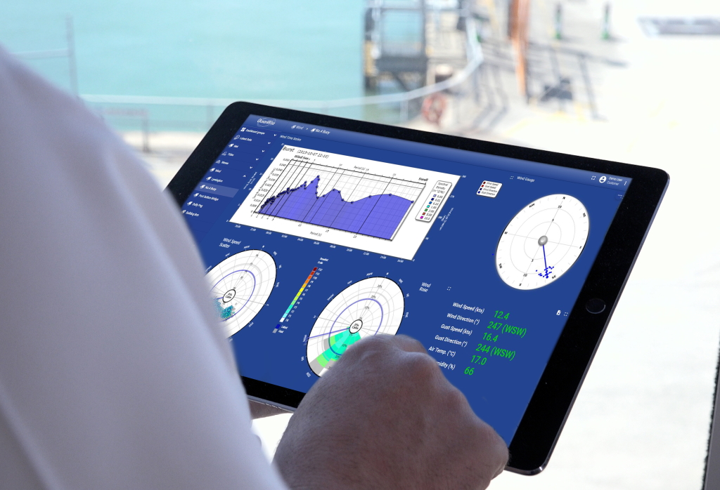
Port-Log is a powerful tool for environmental monitoring and data management, but are you using all its features to their full potential?

Here are some lesser-known capabilities that can help you unlock even more value:


1. Monthly Statistics (Reports page)

Quickly review data in a clear, easy-to-read summary. Perfect for reporting, analysis, and planning. Easily spot trends, highlight peaks, check data validity, and identify other key readings without digging through raw data.

VTS, Dover Port with Port-Log ‘latest’ page on screen top middle left

2. Data Sharing Extensions

Share real-time data with other port users—such as dredging contractors—securely and efficiently. Real-time data sharing and collaboration is easy and cost-effective with Port-Log Connect.


3. Forecasting Extension

Combine live data with tide or weather forecasts to plan operations more effectively. See predicted conditions alongside your real-time measurements for smarter decision-making with the Forecasting Extension.


4. API Integration

Connect Port-Log with third-party systems or sensors. Add Coastal Channel Observatory or Cefas buoy wave data (with permission) to your Port-Log subscription. You can also send your real-time data to third parties, such as weather forecasting services, to help improve forecasts. Learn more about Cefas Buoy Integration here.


5. Buoy Page

Track your Wave or Data Buoy and receive alerts if it moves away from its intended location. You can also monitor battery life, last known position, and key data such as temperature.


6. Port-Log Map Page

Visualize your sensors and data geospatially. Your interactive Port-Log map makes it easy to see where your assets are and how they’re performing

If want to explore how to get the most out of your system please do contact us on info@oceanwise-global.com/ 01420 768262. Follow us and join our newsletter for the latest updates.


Connect With Us

Services

  • Port-Log Data Platform
  • Data Sharing
  • Consultancy & Advice
  • System Design & Integration
  • Servicing & Maintenance
  • Monitoring System Builder
  • Installations & Deployments
  • Environmental Conditions

Company

  • About Us
  • News & Projects
  • Guides & Insights
  • Events
  • Our Team
  • Careers
  • Licenced Partners
  • Sustainability & Environment

Resources

  • Contact Us
  • Brochures, Datasheets and Guides
  • Monitoring Support
  • Case Studies
  • Mapping Site

© 2026 OceanWise. All rights reserved.

Privacy Policy | Terms of Service | Cookie Policy

© OceanWise 2024. OceanWise Limited is an independent company specialising in marine environmental data acquisition, management, publishing and GIS.
Registrar of Companies of England and Wales No. 7206926 and Companies Registration Office Ireland No. 641571.

Terms & Conditions | Privacy Notice | Contact Us

OceanWise HelpBot

Still need help?