OceanWise News & Views
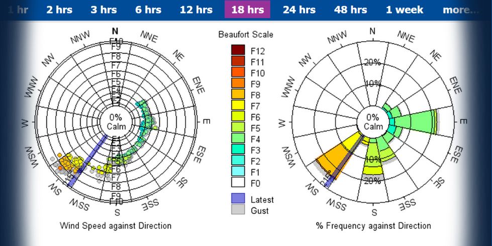
Read or download our quick guide for harbour masters, pilots and marine operators who carry responsibility for safe navigation and efficient operations every day. Should I be measuring currents? If you’re thinking about currents and want to know why you should be considering currents, how to start and who could benefit, then this article […]
Read more
The latest version of our quarterly newsletter is out now! In this issue delve into: Enhancing Pilot Safety with real-time wave data How GNSS Levelling improves tide-gauge accuracy How to unlock the power of Port-Log A review of EMODnet 2025 conference …and more! Read all these articles and find our previous newsletters here
Read more
The ocean covers more than 70% of our planet, yet much of it remains unmapped in detail. Traditional marine mapping can be slow, labour-intensive, and costly. Enter GeoAI a modern approach that fuses artificial intelligence with geospatial data to revolutionise how we understand and monitor our seas. With the use of AI, we can now map the seas faster, smarter, and with more insight. What is GeoAI? GeoAI, […]
Read more
From all of us at OceanWise, we wish you and your families a very Merry Christmas! Today we celebrated in true OceanWise style—with a buffet lunch, a round of Secret Santa Pong (yes, it’s a new thing that we have invented – and highly recommend!), a Champagne raffle and our annual Christmas Quiz. Safe to […]
Read more
Port-Log is a powerful tool for environmental monitoring and data management, but are you using all its features to their full potential? Here are some lesser-known capabilities that can help you unlock even more value: 1. Monthly Statistics (Reports page) Quickly review data in a clear, easy-to-read summary. Perfect for reporting, analysis, and planning. Easily […]
Read more
Last week our Information Systems Manager Andrew Bell attended the 2025 EMODnet Conference. EMODnet is a ‘comprehensive in situ marine data service in Europe, offering a wealth of in water Ocean observations, data and data products, spanning the coast and oceans’. This conference an important event for those of us involved in marine data, ocean […]
Read more
When pilots from Peel Ports Group head out into the Irish Sea to board incoming vessels, timing is everything. The sea state can shift quickly, and rough waves can make pilot transfers not just difficult, but dangerous. A Cefas buoy already stationed near a Peel Ports boarding point was collecting valuable wave data — but that information wasn’t easily accessible […]
Read more
When we talk about sea level rise, most people picture water creeping higher along our coasts. But there’s another factor at play that’s less obvious — the ground itself can move too. That’s where GNSS levelling (Global Navigation Satellite System) comes in. It’s helping scientists, marine operators and engineers make environmental data, such as […]
Read more
Recently our Chairman Dr Mike Osborne took part in the MEDIN hosted webinar titled “Interoperability in Action: Data Standards and Marine Applications” which explored the critical role of standardized data practices in enhancing marine data interoperability. The session featured three expert presentations that collectively emphasized the importance of consistent data management across marine sectors. Roseanna […]
Read more
We welcomed local Member of Parliament Damian Hinds to our offices in Alton in September, after an invitation which was organised by the Society of Maritime Industries (SMI), aimed at connecting MPs with innovative maritime businesses in their constituencies. Damian Hinds, MP for East Hampshire, said: “One of the great things about my role […]
Read more