OceanWise News & Views
To mark the launch of the Smart Ports Alliance Data Academy, founder Kevin Martin is joined by our Managing Director Caroline Levey, in an interactive live broadcast to talk about the importance of data management for any business, and some simple tips to get started. This online event takes place on the 2nd of February […]
Read more
We are really pleased to announce that Fred Ashcroft has joined our growing team as a junior field engineer, bringing with him a great mix of practical skills and marine experience. Fred recently moved ashore having spent over a year training to be an officer on commercial vessels. Fred will be supporting the Monitoring Team […]
Read more
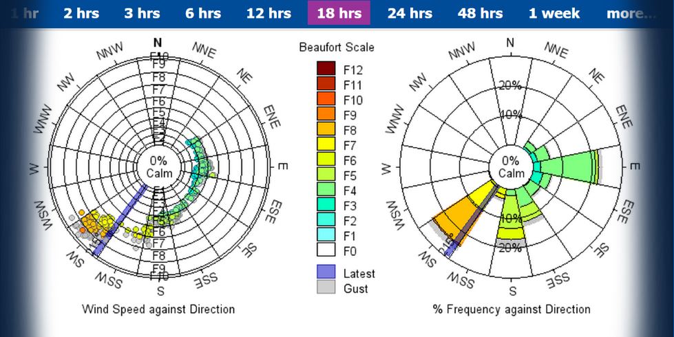
In 2021 Peel Ports, one of the largest port groups in the UK, signed a Service Level Agreement (SLA) with OceanWise to deliver consistent, reliable servicing and maintenance to the wide variety of environmental monitoring systems and sensors that Peel Ports have in place across all Peel Ports sites. The Peel Ports Group is made […]
Read more
Following our announcement earlier this year in August that we won a contract with the Port of Tyne to provide an environmental monitoring solution to support operational decision making across the Port’s jurisdiction. We are proud to have received the following excellent feedback so far: “The introduction of OceanWise this summer has already proved invaluable, […]
Read more
We are excited to announced that we have been chosen as one of 10 SMEs to take part in their Maritime Accelerator Programme. This brand new programme which is created and supported by the Connect Places Catapult is also supported by several specially selected partners. Read more about the programme, other cohorts and the work […]
Read more
Amy Thompson will be speaking at the upcoming Marine Measurement Forum (MMF65) hosted by Aquatec Group on the 30th November 2022. Amy will be speaking on the ‘Evolution in the measurement of Mean Sea Level’ drawing on our experience in this area and recent projects with the UKHO. More details on the MMF can be […]
Read more
OceanWise will be running a free webinar for all members of the GIS Marine Data Framework from the Scottish Government. Members will all be contacted by Scottish Government and invited to attend. This webinar will include an introduction to the framework, case studies and an overview of the marine mapping products included in the agreement. […]
Read more
Following our recent Customer Research Survey during which we committed to donating £5 for every completed survey, we are delighted to have finished the project AND made a considerable donation to Project Seagrass. The money OceanWise donate will go towards helping Project Seagrass achieve their mission to secure the future for seagrass globally as well […]
Read more
OceanWise signs up new partner Sennen Tech. Sennen Tech develops software applications for the renewables market. As part of the Offshore Wind “work management tool”, OceanWise’s “ENC WMS” forms a key part of the Sennen system, allowing clients to monitor offshore operations effectively. This is useful for the Marine Coordinators as within our system they […]
Read more
Our Amy Thompson has recently written a fantastic piece for Green Port’s Autumn Magazine -titled “Marine Monitoring – The Big Picture” in which she discusses the demand for environmental data and how it is evolving. It includes advice on choosing the best system and considerations around how to handle and manage your data. Read Amy’s […]
Read more