OceanWise News & Views
We are very pleased to announce that Dr Mike Osborne, Managing Director of OceanWise Ltd, will be making a Keynote address on “Data Management to Hydrography” at the upcoming HydroSea 18 in Malaysia (19th-20th September). “Hydrographers have been managing data for a long time, since the first sounding was taken, or chart compiled. Important aspects […]
Read more
In co-operation with IMarEST we will once again be running a One-day Marine Data Management Awareness Course on Tuesday 16th October 2018. This will be taking place at IMarEST headquarters: 1 Birdcage Walk, London, SW1H 9JJ from 09:30 – 16:30. On this course you will learn: What Marine Data Management is, why data is such […]
Read more
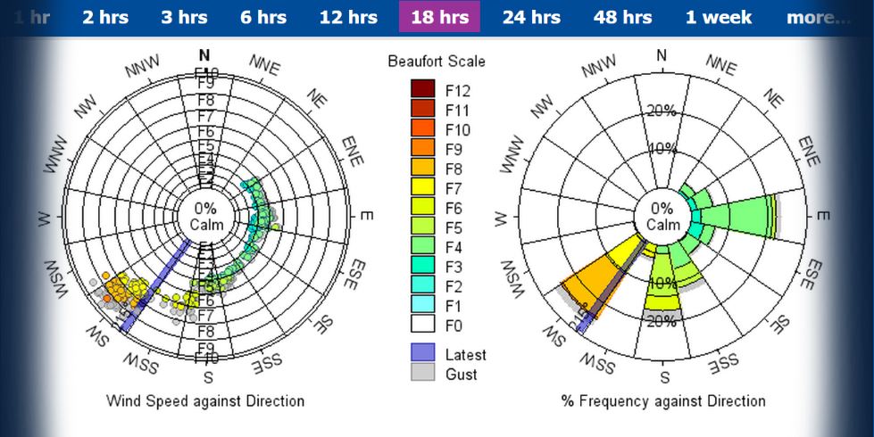
A Gill Instruments supplied weather station on the Solent – Calshot Spit Light Float – now has the OceanWise’ data telemetry system which is transmitting accurate real-time weather data direct from the light float to the OceanWise Environmental Data Sharing and Publishing platform, Port-Log.net. The OceanWise system, which has a proven track record in delivering […]
Read more
OceanWise has added a dynamic software Extension to Maritime Toolbar for Esri ArcMap, which powerfully and easily helps the user to manipulate maritime data. This latest extension ‘Object Based Image Analysis’ or ‘RSOBIA’ takes raster imagery and segments the data into geographic areas with similar statistical properties. It interprets the areas and boundaries seen in […]
Read more
We are delighted to announce that we are now officially ISO 9001 accredited. After much hard work from the entire OceanWise team, our Quality Management System (QMS) has been confirmed as meeting the standards of the latest 2015 revision. The International Standards Organisation (ISO) helps businesses to have minimal waste and maximum productivity and sets […]
Read more
We are very pleased to announce that we have been awarded the Framework Agreement for the provision of GIS Marine Data to the Scottish Government until 2022. We will be supplying Marine Mapping Data products and services including Marine Themes Vector, Marine Themes Digital Elevation Model (DEM), Raster Charts and Raster Charts eXcluding Land (XL) […]
Read more
For our annual team building day this year, we all climbed aboard a Sunsail First 40 cruising yacht and enjoyed a beautiful day of sailing in the Solent. We embarked from Port Solent and made our way over towards Cowes, before heading back past the New Forest and Southampton Water. The OceanWise team has a […]
Read more
OceanWise, UK leaders in the provision of intelligent Marine and Coastal Mapping data, has extended its Raster Charts XL dataset to include the Arabian Gulf. Based on the familiar nautical chart series, Raster Charts give contextual marine information dovetailed with terrestrial mapping to provide a rich background layer in support of Marine Planning. Raster Charts […]
Read more
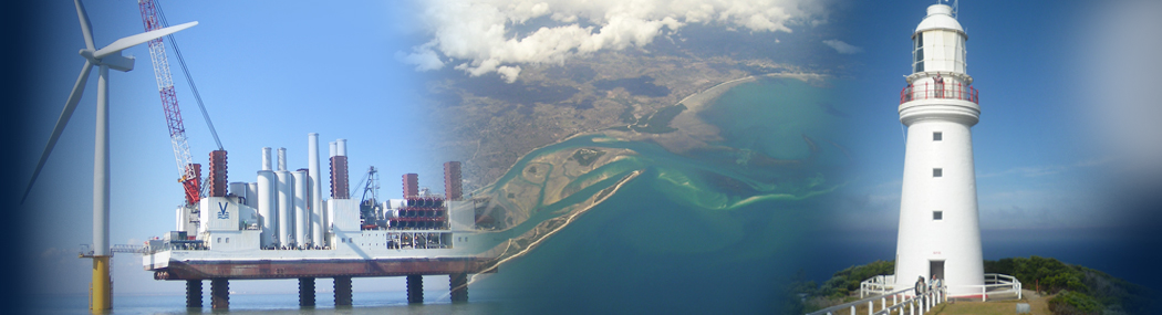
Image Source: Vattenfall. Photographers: Above left Robin Dawe/Perfectly Clear Marketing. Above right Paul Langrock. Vattenfall, the Swedish energy group, have procured OceanWise Raster Charts XL (eXcluding Land) as a seamless Web Map Tile Service (WMTS) for Northern Europe. Based on standard nautical charts, and therefore with a familiar look and feel, Raster Charts XL are […]
Read more
The Royal Yachting Association (RYA) is the latest customer to take our Raster Charts Excluding Land (XL) product joining a prestigious list of Marine industry organisations such as Vattenfall, Qatar Petroleum, Scottish Government and the Department for Agriculture, Environment and Rural Affairs (DAERA) in Northern Ireland. Raster Charts provide intelligent marine mapping data delivering a […]
Read more